
Файл:Madhhab Map2.png
Размер этого предпросмотра: 800 × 388 пкс. Другие разрешения: 320 × 155 пкс | 640 × 310 пкс | 1245 × 604 пкс.
Исходный файл (1245 × 604 пкс, размер файла: 50 Кб, MIME-тип: image/png)

|
Это изображение неизвестного типа «religion map» желательно воссоздать или аккуратно преобразовать в векторный формат SVG. Это даёт несколько преимуществ, прочитать о которых подробнее вы можете на странице Commons:Media for cleanup. Если вам уже сейчас доступна векторная версия данного изображения, загрузите её, пожалуйста, а затем замените этот шаблон на следующий: {{Vector version available|Имя загруженного файла.svg}}.
|
Краткое описание
| Описание |
العربية: المدارس الفقهية الإسلامية الرئيسيّة وانتشارها حول العالم (لغة إنجليزية)
فارسی: نقشهٔ پراکندگی مذاهب فقهی اسلام در جهان (انگلیسی)
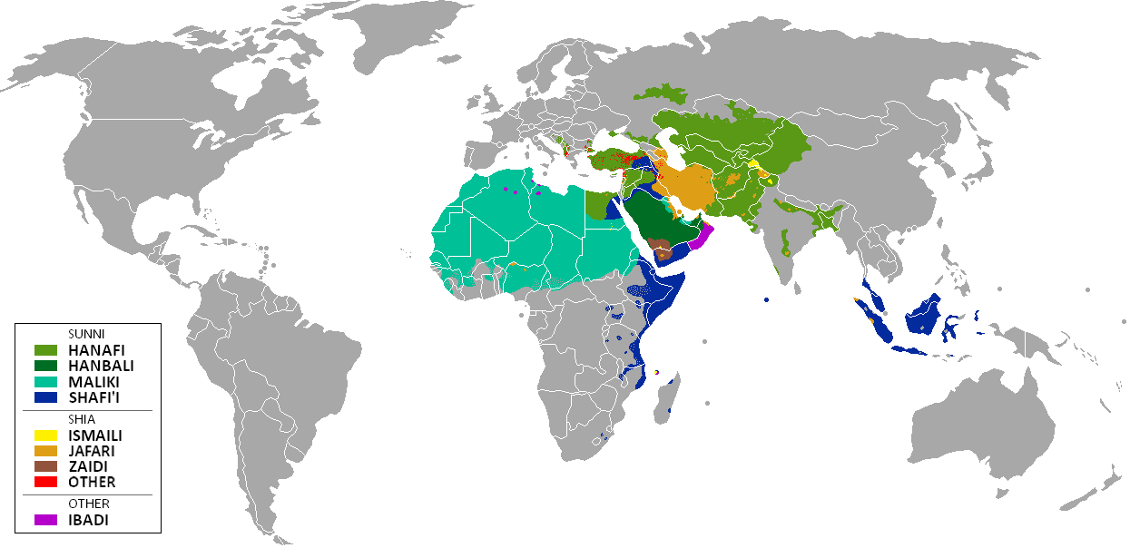
English: The distribution of the predominant Islamic madhhab (school of law) followed in majority-Muslim countries and regions (English)
Bahasa Indonesia: Distribusi penyebaran agama islam berdasarkan Mahdab di negara-negara dan wilayah dunia |
| Дата | |
| Источник | Own work by uploader from a blank-map, based on this source: Legal Sources and various other sources |
| Автор | Ghibar |
| Другие версии |
Производные работы от этого файла: |
Лицензирование
Я, владелец авторских прав на это произведение, добровольно публикую его на условиях следующих лицензий:
Этот файл доступен по лицензии Creative Commons Attribution-Share Alike 3.0 Unported.
- Вы можете свободно:
- делиться произведением – копировать, распространять и передавать данное произведение
- создавать производные – переделывать данное произведение
- При соблюдении следующих условий:
- атрибуция – Вы должны указать авторство, предоставить ссылку на лицензию и указать, внёс ли автор какие-либо изменения. Это можно сделать любым разумным способом, но не создавая впечатление, что лицензиат поддерживает вас или использование вами данного произведения.
- распространение на тех же условиях – Если вы изменяете, преобразуете или создаёте иное произведение на основе данного, то обязаны использовать лицензию исходного произведения или лицензию, совместимую с исходной.

|
Разрешается копировать, распространять и/или изменять этот документ в соответствии с условиями GNU Free Documentation License версии 1.2 или более поздней, опубликованной Фондом свободного программного обеспечения, без неизменяемых разделов, без текстов, помещаемых на первой и последней обложке. Копия лицензии включена в раздел, озаглавленный GNU Free Documentation License. |
Вы можете выбрать любую из этих лицензий.
| Аннотации | Это изображение аннотировано: Просмотреть аннотации на Викискладе |
История файла
Нажмите на дату/время, чтобы увидеть версию файла от того времени.
| Дата/время | Миниатюра | Размеры | Участник | Примечание | |
|---|---|---|---|---|---|
| текущий | 14:24, 23 января 2018 | | 1245 × 604 (50 Кб) | Maphobbyist | Revert. Jafari school more widespread in northern Sumatra according to sources, than mere dots. |
| 14:55, 30 мая 2016 |  | 1245 × 604 (2,87 Мб) | Riyantojayadi | Madhhab majority of Aceh region[1] and West Sumatra/Minangkabau region[2] in Indonesia are Syafii school of Sunni. There are some tribe's ritual in this area that are based on Shia such tabot, however, for religion, they are practicing . Shia communiti... | |
| 16:45, 11 января 2015 |  | 1245 × 604 (50 Кб) | AnonMoos | Reverted to version as of 02:11, 30 July 2014 -- see User_talk:Peaceworld111 | |
| 13:24, 11 января 2015 |  | 1245 × 604 (52 Кб) | Peaceworld111 | Re-added Ahmadi. It's a sect of Islam per reliable sources and is not a mere dot. See talk page. | |
| 05:10, 11 января 2015 |  | 1245 × 604 (50 Кб) | AnonMoos | Reverted to version as of 02:11, 30 July 2014 -- change not discussed on image talk page, possibly problematic, see user talk page | |
| 21:11, 8 января 2015 |  | 1245 × 604 (52 Кб) | Peaceworld111 | Added Ahmadi | |
| 05:11, 30 июля 2014 |  | 1245 × 604 (50 Кб) | KronosLine | Fixed Russia | |
| 21:36, 20 июля 2014 |  | 1245 × 604 (63 Кб) | Calthinus | distribution of Bektashis in Albania fixed, distribution of Muslims in Greece & Macedonia (esp the ethnic Slav Macedonian Muslims, whose distribution had previously not been marked) fixed, various other fixes... | |
| 20:50, 19 октября 2013 |  | 1245 × 604 (50 Кб) | Hibernian | Damn it, that revert button doesn't do what I thought it does. Here's what I meant to change it to. This version also changes the Kerala Muslims to Shafi'i as was suggested on the talk page. | |
| 20:37, 19 октября 2013 |  | 1245 × 604 (55 Кб) | Hibernian | Reverted to previous version. It is totally illogical to not show the borders of states with limited recognition (practically every map on Wikipedia depicts these entities), it has nothing to do with the official UN definitions, but with showing reality. |
Использование файла
Нет страниц, использующих этот файл.
Глобальное использование файла
Данный файл используется в следующих вики:
- Использование в bn.wikipedia.org
- Использование в bn.wikivoyage.org
- Использование в en.wikipedia.org
- Использование в en.wikivoyage.org
- Использование в he.wikipedia.org
- Использование в hi.wikivoyage.org
- Использование в id.wikipedia.org
- Использование в incubator.wikimedia.org
- Использование в it.wikivoyage.org
- Использование в ja.wikipedia.org
- Использование в mzn.wikipedia.org
- Использование в uk.wikipedia.org